

On this page
- GR10 and GR11: The Classic Long-Distance Routes
- Day Hikes from Ordesa y Monte Perdido National Park
- Aigüestortes i Estany de Sant Maurici: Lakes and Granite Peaks
- Valley of Arán: High-Altitude Alpine Adventures
- Essential Gear and Safety Considerations for 2026
- Where to Stay: Mountain Refugios and Base Towns
- Transportation and Trail Access Points
- Best Time to Hike: Weather Windows and Seasonal Conditions
- Budget Planning for Pyrenees Hiking Adventures
- Frequently Asked Questions
💰 Click here to see Spain Budget Breakdown
💰 Prices updated: June, 2026. Budget figures are estimates — always verify before travel.
Exchange Rate: $1 USD = €0.86
Daily Budget (per person)
Shoestring: €50.00 – €140.00 ($58.14 – $162.79)
Mid-range: €100.00 – €240.00 ($116.28 – $279.07)
Comfortable: €240.00 – €450.00 ($279.07 – $523.26)
Accommodation (per night)
Hostel/guesthouse: €10.00 – €50.00 ($11.63 – $58.14)
Mid-range hotel: €70.00 – €130.00 ($81.40 – $151.16)
Food (per meal)
Budget meal: €7.00 ($8.14)
Mid-range meal: €25.00 ($29.07)
Upscale meal: €80.00 ($93.02)
Transport
Single metro/bus trip: €3.00 ($3.49)
Monthly transport pass: €23.00 ($26.74)
Spain‘s Pyrenees hiking scene has transformed dramatically since the post-pandemic hiking boom, with trail overcrowding becoming a real concern by 2026. Popular routes now require advance refugio bookings months ahead, and some national parks have introduced visitor quotas during peak summer weeks. The good news? New trail infrastructure and improved public transport links mean accessing these majestic peaks is easier than ever.
GR10 and GR11: The Classic Long-Distance Routes
The GR11 remains the crown jewel of Pyrenees hiking, stretching 820 kilometres from the Mediterranean to the Atlantic entirely on Spanish soil. Unlike its French counterpart GR10, the Spanish route tackles the highest and most dramatic terrain, crossing beneath towering peaks like Aneto (3,404m) and Posets (3,375m).
Most hikers tackle sections rather than the full 45-day traverse. The Benasque to Vielha section offers the most spectacular high-alpine scenery, with three days of walking above 2,000 metres elevation. The morning mist lifting from Estany de la Restanca lake while ibex graze on nearby ridges creates an almost otherworldly atmosphere that defines Pyrenees hiking.
The GR11’s eastern sections through Aigüestortes and Ordesa national parks see the heaviest traffic. Since 2025, these stretches require advance permits during July and August weekends. The western portions through Navarra remain blissfully uncrowded, offering equally stunning scenery with traditional Basque villages as overnight stops.
Day Hikes from Ordesa y Monte Perdido National Park
Ordesa National Park offers Spain’s most accessible high-mountain hiking, with well-maintained trails and reliable public transport from nearby towns. The classic Cola de Caballo waterfall trail follows the valley floor for 16 kilometres, gaining just 400 metres elevation while showcasing limestone cliffs that soar over 1,000 metres overhead.

For serious hikers, the ascent to Monte Perdido summit via the Goriz refugio represents the park’s ultimate challenge. This two-day adventure requires technical scrambling skills and proper equipment, but rewards with 360-degree views across both Spanish and French Pyrenees. The sound of marmots whistling echoes across the high cirques as you approach the 3,355-metre summit.
The Añisclo Canyon offers an entirely different experience, with riverside trails winding through narrow gorges carved by glacial action. Spring snowmelt creates thundering waterfalls that spray hikers walking the canyon floor trail, providing welcome cooling on hot summer days.
Aigüestortes i Estany de Sant Maurici: Lakes and Granite Peaks
Catalonia’s only national park specializes in high-altitude lake hiking, with over 200 alpine tarns scattered across granite basins. The Estany de Sant Maurici circuit provides an excellent introduction, combining easy lakeside walking with optional summit extensions to peaks like Els Encantats.
The park’s western sector around Boí offers more challenging terrain and fewer crowds. The ascent to Estany Llong requires steady climbing through pine forests before emerging onto open alpine terrain dotted with pristine lakes. Wild camping is strictly prohibited, but the natural beauty justifies day-trip logistics from valley accommodations.
Advanced hikers should attempt the Carros de Foc circuit, a demanding multi-day traverse connecting the park’s major refugios. This 55-kilometre route crosses eight mountain passes above 2,000 metres, showcasing the full diversity of Pyrenean landscapes from dense forests to barren scree slopes.
Valley of Arán: High-Altitude Alpine Adventures
The Val d’Aran offers a unique Pyrenean experience, with Occitan culture and French-influenced architecture creating an atmosphere distinct from typical Spanish mountain towns. Baqueira-Beret ski resort transforms into a hiking paradise during summer months, with chairlifts providing easy access to high ridges.
The Saboredo circular route combines multiple ecosystems within a single day hike, starting from Arties village and climbing through beech forests before emerging onto alpine meadows surrounding pristine mountain lakes. The descent through the Ruda valley passes traditional stone huts still used by local shepherds.

For ultimate high-altitude challenges, the approach to Aneto, Spain’s highest peak, begins from the Renclusa refugio in nearby Benasque valley. This technical ascent requires glacier travel experience and proper equipment, but standing atop the 3,404-metre summit provides unparalleled views across the entire Pyrenean range.
Essential Gear and Safety Considerations for 2026
Pyrenean weather changes rapidly at altitude, making proper gear selection critical for safe hiking. Temperatures can drop 20 degrees between valley floors and summit ridges, while afternoon thunderstorms develop quickly during summer months. Essential items include waterproof layers, insulating clothing, sturdy hiking boots, and navigation equipment.
The new EU-wide emergency beacon requirement affects international hikers since January 2026. Personal locator beacons (PLBs) or satellite communication devices are now mandatory for solo hikers on routes above 2,500 metres. Spanish mountain rescue services can levy fines up to €3,000 for unprepared hikers requiring expensive helicopter evacuations.
Weather apps specific to mountain regions provide more accurate forecasts than general services. The Spanish meteorological service (AEMET) offers detailed mountain weather including avalanche bulletins during winter months and thunderstorm probability during summer hiking season.
Navigation and Trail Marking
Most major Pyrenean trails follow standard European hiking markers, with red and white paint blazes indicating GR (Grande Randonnée) routes. Local trails use yellow and white markings, while blue indicates winter routes suitable for snowshoes or cross-country skiing.
GPS devices or smartphone apps with offline maps are essential backup navigation tools, especially on high ridges where fog can obscure trail markers. The IGN (Instituto Geográfico Nacional) publishes detailed topographic maps covering all major hiking areas at 1:25,000 scale.

Where to Stay: Mountain Refugios and Base Towns
Pyrenean refugios range from basic stone shelters to comfortable mountain lodges with hot meals and private rooms. Popular refugios like Goriz in Ordesa or Restanca in Aigüestortes require reservations months in advance during peak season. Booking opens January 1st each year, with prime July and August dates filling within hours.
Base towns provide alternative accommodation for hikers preferring valley comfort over mountain simplicity. Benasque offers the widest selection of hotels and restaurants, serving as headquarters for Aneto and Posets area hiking. The town’s gear shops stock everything from crampons to emergency bivouac equipment.
Smaller villages like Torla (Ordesa gateway) or Espot (Aigüestortes access) provide authentic mountain atmosphere with family-run guesthouses and traditional restaurants. These locations offer better value than major resort towns while maintaining easy trail access.
Refugio Etiquette and Booking
Spanish mountain refugios operate on different principles than Alpine huts, with most offering restaurant services and comfortable sleeping arrangements. Dinner reservations are essential, as refugio kitchens typically serve meals at fixed times between 7-9 PM.
Wild camping remains prohibited in national parks but is generally tolerated above 2,000 metres elevation outside protected areas. Bivouac camping (single night, minimal impact) receives broader acceptance than extended camping with multiple tents and cooking equipment.
Transportation and Trail Access Points
The new high-speed rail connection to Huesca, completed in late 2025, dramatically improves Pyrenees access from major Spanish cities. From Madrid, travelers can reach Huesca in 2.5 hours, then connect via regional buses to trailheads in Ordesa and Benasque valleys.
Barcelona remains the primary gateway for eastern Pyrenees hiking, with direct bus services to Aigüestortes and Val d’Aran. The summer-only bus route from Barcelona Estació del Nord to Espot operates June through September, providing car-free access to Catalonia’s national park.

Local taxi services connect major towns to trailheads, though costs can be substantial. Shared taxi arrangements through refugio managers often provide economical solutions for groups accessing remote starting points.
Parking and Vehicle Considerations
Summer parking restrictions now affect most popular trailheads, with Ordesa implementing a reservation system for private vehicles during peak periods. The shuttle bus from Torla village operates every 20 minutes during summer months, providing reliable access while reducing traffic congestion in the national park.
Rental car agencies in major cities offer vehicles suitable for mountain road access, though insurance policies may exclude certain unpaved forest roads leading to remote trailheads. Check rental agreements carefully before driving to isolated starting points.
Best Time to Hike: Weather Windows and Seasonal Conditions
July and August provide the most reliable weather for high-altitude Pyrenean hiking, with snow-free conditions on most trails above 2,500 metres. However, these months also bring peak crowds and afternoon thunderstorm risks. Early morning starts become essential for summit attempts, with most alpinists beginning before dawn to reach peaks by noon.
September offers excellent hiking conditions with stable weather, fewer crowds, and spectacular autumn colors in deciduous forests. Night temperatures drop significantly, requiring warmer sleeping bags for refugio stays and making proper layering systems crucial for day hiking.
Late spring hiking (May-June) provides opportunities for snow-climbing adventures and waterfall viewing, but requires careful route planning and avalanche awareness. Many high passes remain snow-covered through June, making microspikes or light crampons necessary equipment.
Climate Change Impacts
Rising temperatures have dramatically altered Pyrenean hiking seasons, with traditional summer conditions now starting earlier and lasting longer into autumn. Glacial retreat on peaks like Aneto requires updated route information, as previously standard approaches may no longer be safe due to increased rockfall from melting permafrost.

Water sources that historically flowed year-round now dry up during hot summer periods, making water carrying capacity planning more critical than in previous decades. Local refugio managers provide current water situation updates for their areas.
Budget Planning for Pyrenees Hiking Adventures
Pyrenean hiking costs vary dramatically based on accommodation choices and activity level. Budget travelers using camping or basic refugio dormitories can expect daily expenses of €35-50, while those preferring comfortable hotels and restaurant meals should budget €80-120 per day.
Budget Range Breakdown (per person/per day):
Budget (€35-50):
- Refugio dormitory bed: €18-25
- Self-catered meals: €12-20
- Local transport: €5-8
Mid-range (€50-80):
- Small hotel or refugio private room: €35-55
- Mix of restaurant and self-catered meals: €20-30
- Occasional taxi or guided activities: €8-15
Comfortable (€80-120):
- Quality hotel or mountain lodge: €60-90
- Restaurant meals with local specialties: €25-40
- Private transport and equipment rental: €15-25
Gear rental in mountain towns provides cost-effective alternatives to purchasing specialized equipment. Technical gear like crampons, helmets, and avalanche transceivers rent for €8-15 per day from shops in Benasque, Torla, and Baqueira.
Multi-day hiking permits and national park entries remain free throughout the Spanish Pyrenees, though some refugios charge nominal environmental fees. The only significant additional costs involve cable car or chairlift access where available.
Frequently Asked Questions
Do I need hiking experience to tackle Pyrenean trails?
Many Pyrenean trails suit beginner hikers, particularly valley walks in Ordesa and lakeside routes in Aigüestortes. However, high-altitude routes and peak ascents require solid fitness and mountain experience due to weather exposure and technical terrain.
Are Pyrenean trails well-marked and easy to follow?
Major GR routes feature excellent marking with red and white blazes, while local trails use yellow and white markers. Fog and winter conditions can obscure markings, making GPS backup navigation essential for safety.
Can I hike the Pyrenees without speaking Spanish?
English is widely spoken in tourist areas like Benasque and Baqueira, while refugio staff typically speak multiple languages. Learning basic Spanish phrases helps in smaller villages and emergency situations.
What’s the difference between Spanish and French Pyrenean hiking?
Spanish Pyrenees generally offer more dramatic high-altitude terrain and wilder landscapes, while French routes provide better refugio infrastructure and more consistent trail maintenance. Spanish national parks have stricter camping regulations.
How dangerous are bears and wolves in the Pyrenees?
Brown bear populations exist in small numbers but pose minimal threat to hikers. Wolves are extremely rare and avoid human contact. Standard food storage practices and making noise while hiking prevent wildlife encounters.
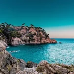
📷 Featured image by Harrison Fitts on Unsplash.